The Narrative Power of Maps
Frontex, an example of misinformation
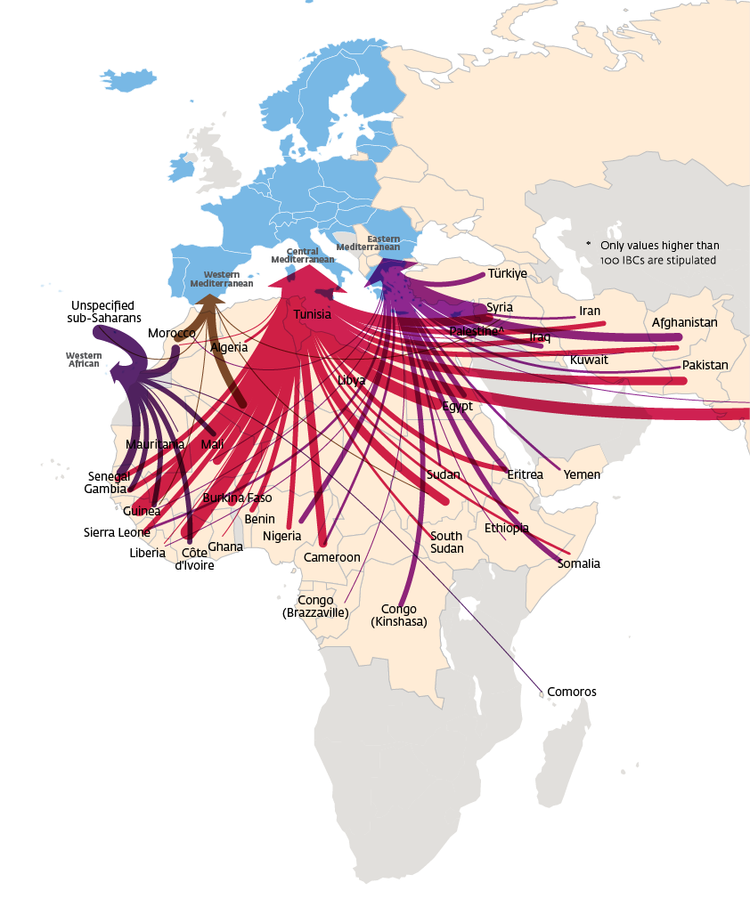
Every three months, the European Border and Coast Guard Frontex, releases a map documenting “detections of illegal border-crossing” along Central Mediterranean and Western Balkan migration routes into Europe (see Figure 1 as a visual example). These maps have been strongly criticised by migration scholars as “mythological” and “surrealist”, in their eurocentric and defensive portrayal of contemporary migrations towards Europe (see Van Houtum and Bueno Lacy 2020a).
In order to become familiar with the dangers of map making and prepare for the creation of a critical, plural mapping of migrations into, out of and within Europe, the Lives in Motion education team has been analysing these Frontex maps with one of MIDI’s Geopolitics of Migrations students. All this to understand how such maps cement the eurocentric, white supremist power structures in migration narratives that we want to dismantle and counteract with #Livesinmotion. This article summarises our critical deconstruction of an exemplary Frontex map, examining how—what scholars Van Houtum and Bueno Lacy (2020a) have defined as the map’s “GRID”, “ARROWS” and “FRAME”—posit migration as a mono-directional, threatening phenomenon that Europe must defend itself from. This article puts into practice the map reading keys developed by Van Houtum and Bueno Lacy (2020a,b) in order for the Lives in Motion resource development team to help encourage the eventual development of other, contrasting forms of map creation that critically questions the Frontex map making model (see e.g. Van Houtum, 2024).
As you follow us through this step by step deconstruction, remember that maps are never inherently factual. On the contrary, maps always remove or simplify elements of a real life space and situation and visualise the world from the specific social, cultural and political perspective of their maker. In fact, as professor and cartographer Mark Monmonier says: “Maps always lie.” (Columbro 2021). Since maps are always a symbolic and necessarily reductive interpretation of reality, they will always be informed by the choices, prejudices and intentions of their makers and they will always be visual representations of what philosopher John Searle calls “institutional facts”, “facts that require human institutions for their existence” (Searle 1999). Thus the key to critically reading a map is to always ask: “Why has the maker decided to represent reality in this way?” “What are their intentions?” (Van Houtum, 2024).
""THE GRID"
As explained by Van Houtum and Bueno Lacy (2020a), the “grid” refers to the map’s demarcation of territory. It posits the European continent as the centre and focus of the world and displays land as a series of separate, delineated “compartments” which are defined by their national borders (Van Houtum and Bueno Lacy 2020a). The “grid” also makes people invisible: they are simply an anonymous and inseparable part of the territories and states in which they are “compartmentalised” (Ibid.).
"THE ARROWS"
Van Houtum and Bueno Lacy (2020a) continue to explain that the “arrows” on the Frontex map and their sharp, pointed heads depict “risks”, marking the act of migration as “penetratively” invasive and dangerous. Van Houtum and Bueno Lacy: “They make the transit of people seeking shelter or work look as dangerous as incoming armed forces” (see also Jones, Reece and Fluri 2020: 158). Furthermore, the swift lines sweeping up to the arrow’s swollen heads suggest quick, automatic and continuous journeys across the African continent towards Europe, as if migrations are taking place in an uninterrupted, unhindered flow (Van Houtum and Bueno Lacy, 2020a).
"THE FRAMING"
The disproportionate size of the arrow’s head and its dominant position in relation to the rest of Europe (it’s made to look as big as the entire Iberian Peninsula, France, Germany and Britain) (Jones, Reece and Fluri 2020; van Houtum and Bueno Lacy 2020a), suggests the presence of uncontainable masses of people marching from Africa, the Middle East and Asia to overwhelm Europe when in actual fact only 3.3% of the world’s population lives outside of their country of birth and undocumented migrants make up only 0.1-0.7% of EU’s total population (Van Houtum and Bueno Lacy 2020a). The contrast of colours in this frame: the dark red of the moving arrows typically suggesting abnormality, danger, warning, sexual promiscuity, anger and fear against the open, peaceful blue of Europe brings home the construction of undocumented migration as an intensive security threat to peace and order (Van Houtum and Bueno Lacy 2020a).
The “grid”, “arrows” and “framing” of the map transform the question of undocumented migration into a fast-moving, overwhelming source of menace for Europe, when in reality irregular migration is a numerically small phenomenon and paradoxically one of people’s only ways to exercise their right to asylum (Art. 18 Charter of Fundamental Rights of the European Union) and right to leave one’s country (Art. 12, International Covenant on Civil and Political Rights): all the individuals of the world holding passports listed on the ‘negative’ Schengen list (135 out of 195 countries) have almost no chance of receiving a visa to enter the EU regularly on a humanitarian or work-related basis (Van Houtum and Bueno Lacy, 2020b). It is this discrimination and construction of, what Van Houtum and Bueno Lacy (2020b) call, “paper borders”, a clear violation of Article I of the Universal Declaration of Human Rights (“all human beings are born free and equal in dignity and rights”) that makes irregular passage to the EU into a necessary and inevitable mode of migration.
Sources
Columbro, Donata (2021) Ti spiego il dato. Milano: Quinto Quarto
Searle, John (1999) The future of philosophy, Philosophical Transactions: Biological Sciences, 354(1392): 2069-2080.
Frontex (2024) Migratory Routes. Available at: https://www.frontex.europa.eu/what-we-do/monitoring-and-risk-analysis/migratory-routes/migratory-routes/ (Accessed: 21/01/2026).
Van Houtum, Henk, Bueno Lacy, Rodrigo (2020a) The migration map trap. On the invasion arrows in the cartography, Mobilities: Issue 2, Special Spection: Reproductive Mobilities, 15(2): 196-219. https://www.tandfonline.com/doi/full/10.1080/17450101.2019.1676031
Van Houtum, Henk & Bueno Lacy, Rodrigo (2020b) The Autoimmunity of the EU’s Deadly B/ordering Regime; Overcoming its Paradoxical Paper, Iron and Camp Borders. Geopolitics, 25(3), 706–733. <https://doi.org/10.1080/14650045.2020.1728743>
Van Houtum, Henk (2024) Free the Map. From Atlas to Hermes: A new cartography of borders and migration, Nai010 Publishers: Rotterdam.